
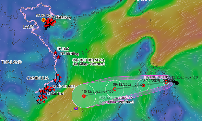
The tropical depression from the central Philippines had been moving west at a speed of 5-10 kilometers per hour in the last 24 hours before accelerating to 15 kph as of 7 a.m. on Sunday. It had a maximum wind speed of 49 kph, according to the National Center for Hydro-Meteorological Forecasting.
By 7 a.m. on Monday, it would be over the waters east of the Philippines’ Palawan Island. It is forecast to maintain the same intensity and shift west-southwest at 15-20 kph before moving farther south due to the influence of cold air from the north.
By 7 a.m. on Tuesday, it is expected to be northeast of the Truong Sa (Spratly) Islands, about 240 km east-southeast of Song Tu Tay Island, maintaining its strength but accelerating to 20 kph.
A predicted trajectory of the tropical depression. Graphics by Vietnam Disasters Monitoring System |
The Hong Kong Observatory reported that the tropical depression currently has wind speeds of 45 kph, which will decrease to 40 kph upon entering the East Sea and further weaken after that.
Starting Monday morning, the southeastern area of the central East Sea, including the northeastern waters of Truong Sa, will experience strengthening winds that can reach a maximum speed of 49 kph and waves of 2–4 meters high. Vessels operating in the area may be impacted.
Local and overseas meteorological agencies have yet to issue forecasts on its effects on mainland Vietnam.
The National Civil Defense Committee on Saturday issued an urgent notice requesting coastal provinces and cities from Quang Tri to An Giang to closely monitor the system, inform vessels in dangerous zones so they can avoid the path, and prepare rescue equipment in case of emergencies.
The hydro-meteorological center noted that this month, the East Sea may see one to two storms or tropical depressions.
Vietnam’s central and south central regions may experience one to two bouts of widespread heavy rain, with high risks of flash floods and landslides. Rainfall in the region spanning from southern Quang Tri to the north of South Central Vietnam is forecast to be higher than the multi-year average.
The El Niño-Southern Oscillation phenomenon over the Pacific Ocean is forecast to continue trending toward La Niña, which is associated with increased rainfall and colder air, until next February and return to neutral conditions from March to May 2026.
The East Sea has seen 15 typhoons and 6 tropical depressions this year, the highest number of cyclonic systems since records began in 1961.
Recently, although Storm Koto weakened at sea, its circulation still brought heavy rain and landslides to the South Central region.
Since the beginning of the year, natural disasters have caused more than VND100 trillion (US$3.79 billion) in damage and left 419 people dead or missing.
Comments are closed.