
Winter has arrived across the country. Cold has started increasing in the morning and evening in North India, but the Meteorological Department has expressed the possibility of snowfall in the next week. According to the forecast of the Meteorological Department (IMD), although the weather will remain clear in North India, northwesterly winds from Pakistan will enter India around October 24. Due to which there will be snowfall in the hilly states of Himachal Pradesh and Jammu Kashmir. Whereas in the plain states like Haryana, Punjab, Chandigarh, snowfall will start and cold winds will blow.
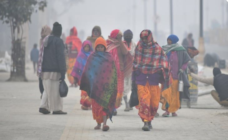
Cold wave will be seen in Delhi, Uttar Pradesh, Bihar
Cold wave will be seen in Delhi, Uttar Pradesh, Bihar. Day temperature may drop to 7 to 8 degrees. On the other hand, cyclonic circulation will form over the Arabian Sea and Bay of Bengal, resulting in formation of low pressure, which will cause strong winds and heavy rainfall over Madhya Pradesh, Chhattisgarh, Bengal, Odisha. , Tamil Nadu, Karnataka, Andhra Pradesh, Maharashtra, Gujarat are on alert. Due to this, cold will increase in other states including Madhya Pradesh, Chhattisgarh, Uttarakhand, Jharkhand, Rajasthan, Gujarat. Let us know how the weather will be in the next one week?
Cyclonic circulation in the Arabian Sea and Bay of Bengal
According to the India Meteorological Department (IMD), a low pressure area will form over the central East Arabian Sea by this evening and over the central Bay of Bengal around October 22. It will continue to rain over South Peninsular India for the next 3 to 4 days. There is no possibility of heavy rain anywhere in the country during the next 7 days, but there may be strong winds in Madhya Pradesh and Chhattisgarh for the next 2 days. Rain warning has been issued in Tamil Nadu and Karnataka today on 20-21 October. A cyclonic circulation is forming over the central eastern Bay of Bengal, which will create a low pressure area.
This low pressure area will move towards Central West Arabian Sea in the next 3 to 4 days
This low pressure area will move towards the central west Arabian Sea in the next 3 to 4 days. Due to which winds will blow at the speed of 35 to 45 and 50 to 55 kilometers per hour in Maharashtra, Karnataka and Kerala adjacent to the Arabian Sea. A cyclonic circulation is also forming over the North Andaman Sea on October 20, which will turn into a low pressure area over East Central Bay of Bengal by October 22. Due to this, there may be heavy rain in Bengal, Odisha, Andhra Pradesh on 23-24 October. The wind will blow at a speed of 30 to 40 kilometers per hour. Due to which the outbreak of cold will increase in the country.
Comments are closed.