
During a meeting with various ministries and coastal localities from Quang Ninh to Binh Thuan on Friday, Mai Van Khiem, director of the National Center for Hydro-Meteorological Forecasting, presented two possible scenarios for the storm’s trajectory.
In the first scenario, with a 60-70% probability, the storm would approach or hit the central coast before turning back to the sea. Coastal areas from Quang Tri to Quang Ngai provinces could experience wind speeds between 39-61 kph, with gusts reaching up to 102 kph.
In the second scenario, with a 30% probability, the storm could penetrate deeper into the central region before reversing out to sea. Under this scenario, stronger winds of up to 88 kph, with gusts of 103-118 kph, are expected in the same coastal areas.
Khiem explained that the storm’s unusual path is influenced by a cold air mass from the north and the formation of another storm off the coast of the Philippines.
“Due to the impact of the offshore storm near the Philippines, Trami’s path and area of influence will continue to change,” he said
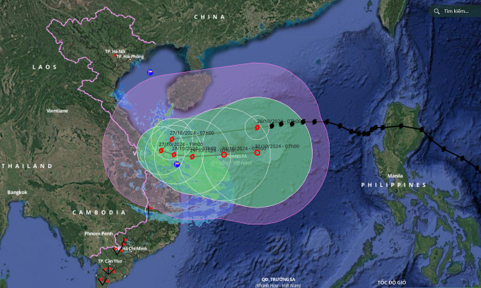
On Saturday morning, the National Center for Hydrometeorological Forecasting reported that the storm was moving west at 20 kph. By 7 a.m. on Sunday, it is expected to reach the offshore waters of the central coast, maintaining wind speeds between 103-117 kph with gusts reaching 150-166 kph.
The storm is forecast to shift slightly southward at 20 kph and by Monday morning, as it approaches the central coast, it is expected to weaken to 88 kph, with gusts of 103-117 kph. At this point, the storm will begin turning back to the sea, moving east at 5-10 kph while continuing to weaken.
Regardless of the scenario, the storm’s impact on central Vietnam is expected to be significant, particularly in terms of rainfall. Trami’s looping movement followed by its reversal out to sea could prolong its effects on land for more than a day. The storm’s radius extends 500-600 km from the eye, with strong winds of 62-74 kph reaching up to 250 km from the center.
Rainfall is forecasted to last until Sunday, with precipitation ranging from 300-500 mm in Quang Tri to Quang Ngai, and peak rainfall exceeding 700 mm in some areas. Other regions like Ha Tinh, Quang Binh, Binh Dinh, and the Central Highlands could see rainfall amounts between 100-200 mm, with some locations exceeding 300 mm.
Rivers such as the Huong, Vu Gia-Thu Bon, and Tra Khuc could experience flooding at warning levels two or three. A level-two warning indicates medium flooding with moderate impacts on residential areas and infrastructure, while a level-three warning signals major floods, posing serious risks to lives, property, and livelihoods.
Deputy Minister of Agriculture and Rural Development Nguyen Hoang Hiep warned that the heavy rainfall could lead to flooding similar to the devastating floods of 2020. He urged coastal provinces to be particularly vigilant about erosion risks due to the prolonged impact of waves, which are approaching the shore at angles of 45-50 degrees.
Hiep advised authorities to extend maritime bans longer than usual and take proactive measures to protect against coastal erosion. In terms of landslide risks, Minister of Agriculture and Rural Development Le Minh Hoan called on localities to expand surveillance using flycams to monitor not only visible cracks but also areas with communities residing along rivers and streams. He emphasized the need to activate community-based disaster management systems to help residents prepare their homes and secure essential supplies.
Storm Trami intensified from a tropical depression off the eastern coast of the Philippines on Tuesday and battered the Philippines the next day.
The storm’s impacts have caused at least 76 deaths in the country and forced nearly 320,000 to evacuate due to heavy rain and flooding, according to AFP.
On Thursday afternoon, it entered Vietnam’s East Sea with maximum winds of 88 kph, marking the sixth storm to hit the region this year.
Comments are closed.