
How the first satellite mission of the year 2026 ‘PSLV-C62’ failed… There was a problem in the third stage… Know the whole reason here
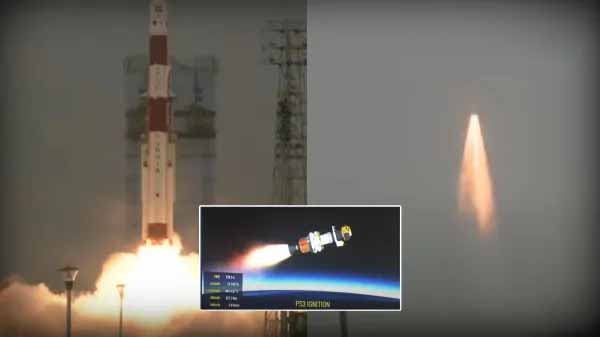
Indian Space Research Organization (ISRO)’s first satellite mission of 2026 ‘PSLV-C62’ has failed. The rocket took off from the space center in Sriharikota, Andhra Pradesh at 10.18 am on Monday carrying 15 satellites.
The objective of the mission was to place the Earth Observation Satellite, EOS-09 Anvesha and 14 co-passenger satellites in a Sun-Synchronous Orbit (SSO) at an altitude of 512 km. ISRO Chief Dr. V Narayanan said that there was a glitch in the third stage of the rocket launching, due to which it lost its way.
8 months ago, on May 18, 2025, ISRO’s PSLV-C61 mission also failed in the third stage due to a technical fault. In this mission, the EOS-09 Earth Observation Satellite was to be placed in a 524 km sun-synchronous polar orbit. This was the 101st launch mission of ISRO.
Out of 15 satellites, 7 are Indian and 8 are foreign.
Of the 15 satellites launched, 7 were built by Hyderabad-based Dhruva Space. The remaining 8 satellites were from France, Nepal, Brazil and UK.
This launch was important for India’s private space sector, because for the first time an Indian private company had such a large stake in the PSLV mission.
This mission was being operated under the supervision of New Space India Limited (NSIL). NSIL is the commercial unit of ISRO.
This was the 64th flight of PSLV
The PSLV rocket was about to complete its 64th flight with the PSLV-C62 mission. PSLV has completed 63 successful flights so far. It is counted among the most reliable launch vehicles in the world.
Missions like Chandrayaan-1, Mangalyaan and Aditya-L1 have been launched with this rocket. The previous mission of PSLV was PSLV-C61, which could not be successful due to technical snag on 18 May 2025.
Anvesha finds the enemies hidden in the jungle bunkers
Anwesha has been developed by the Defense Research and Development Organization (DRDO). It is a spy (intelligence) satellite equipped with advanced imaging capabilities, the purpose of which is for precise monitoring and mapping.
Despite being several hundred kilometers above the ground, it can capture pictures of enemies hidden in bushes, forests or bunkers.
Anwesha satellite works on HRS technology
Anwesha satellite works on ‘Hyperspectral Remote Sensing’ i.e. HRS technology, which detects more spectrum of light. That means it can capture hundreds of subtle colors of light instead of just a few colors.
The subtle color detection by this satellite helps in knowing what the actual picture is of. It is like a scanner that can identify different types of soil, plants, human activity or anything by its different brightness.
Anvesha beneficial for defense sector…
- Satellites are used for purposes like monitoring forests, mining, measuring greenhouse gas emissions. Actually it works like a secret weapon for the armies.
- To know whether an army tank can pass through an area or not, the soil type of that area can be detected through HRS. If there is desert or sticky soil somewhere, it will tell in advance.
- It is often easier to hide behind trees and plants in wooded areas. If an enemy soldier is hidden in a bush or a weapon is hidden under the water of a river, then HRS technology can detect it.
- Through 3D images, simulations can be created using HRS data and photographs during combat. The correct routes for the army and the formation of the enemy army can be understood. The movement of the enemy can be monitored in the border areas.
Till now 6 countries have launched HySIS satellite
Apart from India, America, China, Germany, Japan, Italy and Pakistan have also launched hyperspectral. India had earlier launched its first hyperspectral imaging satellite on 29 November 2018.
The weight of this satellite named HySIS was 380 kg. However, it could detect light in 55 spectral bands. Anwesha is an upgraded version of HySIS and has higher hyperspectral capability.
Comments are closed.