
Clue of Delhi’s lake ‘disappeared’ found in the map of 1932, now a plan is being made for its revival.
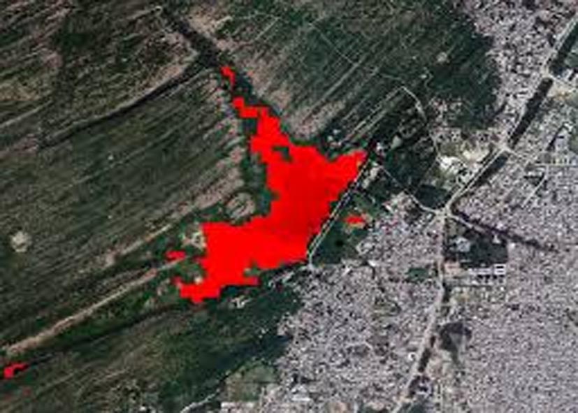
This information is shocking for the people of Delhi that a lake visible in the map of 1932 has now completely disappeared. INTACH, after studying the 1932 map, has identified an approximately 2-mile long stretch of water north of Bhalswa Lake in north-west Delhi. According to experts, this area falls around today’s Kadipur area. However, if seen from modern satellite images, most of the construction work has now taken place on this part of the water and parts of the original form of water of the lake are no longer visible.
INTACH has written to Delhi LG VK Saxena and Delhi Development Authority, drawing attention to the possible revitalization of this area. It has been told in the letter that after studying the old maps and satellite images, it has become clear that a crater still exists in about 10 acres around the Kadipur area, which gives the address of the original reservoir of the lake. Experts believe that there is scope to revive Bhalswa Lake through conservation of this crater and proper water management, which can benefit the ecology and water balance of the region.
What do experts say on the lake?
INTACH Principal Director Manu Bhatnagar, in a letter to Delhi LG VK Saxena and Delhi Development Authority, has said that there is sufficient land to the north-west of the pit in Kadipur area. Manu Bhatnagar suggests that the Bhalswa lake in this area can be revived. Additionally, it has been proposed to convert the surrounding land into a small biodiversity reserve or urban forest.
According to this scheme, local people will get community and environmental benefits. Space will be available to plant approximately 8,000 trees. This project will help in increasing the biodiversity and environmental balance in the area. This initiative will not only conserve the old water bodies of the city but will also strengthen the greenery and natural ecology in Delhi’s urban environment.
INTACH, in its letter written for the revival of Bhalswa Lake in Kadipur area, has said that the natural contour of this area is suitable for storing water. However, authorities need to work collaboratively to revive and conserve the lake. Old maps show that this lake was much larger earlier. However, no response has yet come from Delhi Development Authority on this proposal.
A few years ago, INTACH had also identified another waterbody at Tikri Khurd in Narela, North-West Delhi. Principal Director Manu Bhatnagar said that when he approached the National Green Tribunal in this matter, the officials were directed to revive the waterbody.
In this regard, TOI had reported on the exhibition ‘The Romance of Old Maps: Tracing Lost Landscapes’ held on February 29-March 1. The event featured maps from 1807 to 1984 extracted from the INTACH archives, which revealed the cartographic evolution of the city’s natural systems, waterbodies and routes. These maps also revealed that forests and wetlands in Delhi were gradually converted into concrete structures, affecting the city’s ecosystem.
This research makes it clear that it is possible to identify and revitalize old water sources and natural structures of the city and this can promote ecological conservation and urban greenery.
Follow the LALLURAM.COM MP channel on WhatsApp
Comments are closed.