
Delhi-NCR Weather: Great news amidst the scorching heat! Storm and rain will create panic from this date, big alert from IMD
Monsoon speed up across the country, havoc in these states
The Indian Meteorological Department (IMD) has issued a big update for the countrymen in its latest bulletin. The south-west monsoon has now strengthened its grip in many new parts of the country. According to the Meteorological Department, the monsoon is progressing rapidly and has covered the west-central and east-central Arabian Sea, some more parts of Maharashtra, Karnataka and Andhra Pradesh as well as some areas of Telangana.
It is a matter of relief that the weather conditions remain very favorable during the next 2-3 days, due to which the monsoon can also hit some more parts of the Bay of Bengal, the remaining areas of the northeastern states including Chhattisgarh, Odisha, West Bengal and Sikkim.
New phase of storm and water in Delhi-UP, but first we will have to face severe heat wave.
On the other hand, relief news is also coming for the people of North India who are suffering from the scorching heat and scorching sun. According to IMD, thunderstorms and rain are going to return once again in the national capital Delhi, Punjab, Haryana and Chandigarh. However, before this relief, people will have to endure some more heat.
The Meteorological Department has warned that heat wave may continue to wreak havoc in different parts of Punjab, Haryana, Delhi, Uttar Pradesh and Rajasthan till June 11. During this period, the temperature is expected to remain between 42°C to 44°C for the next few days, due to which it will be difficult to leave the house in the afternoon.
New western disturbance is becoming active, hailstorm alert on mountains
Meteorologists say that a new Western Disturbance is going to become active from the evening of June 11. Due to the effect of this new system, there is every possibility of strong dust storm and light rain in Delhi-NCR. Not only this, due to the impact of this system, there is also a possibility of lightning, strong winds and heavy hailstorm in the hilly areas of Himachal Pradesh, Uttarakhand and Jammu and Kashmir on June 11 and 12.
Mercury reached near 45 degrees in Rajasthan, heavy rain in Pushkar
Two different colors of weather are being seen in Rajasthan at this time. On one hand, while the sun is blazing in many areas, on the other hand, rain has made the weather pleasant in some places. The maximum temperature recorded in Ganganagar was 44.8 degrees Celsius. According to the Meteorological Center Jaipur, in the last 24 hours, light to moderate rain occurred at some places in eastern Rajasthan, while isolated showers occurred in the western part. During this period, maximum rainfall of 50.0 mm was recorded in Pushkar (Ajmer). Due to a cyclonic system over the state, thunderstorm and rain activities are expected to continue in the coming days.
How will the rain be in which corner of the country this week?
According to the weekly report of the Meteorological Department (June 8 to 14), the weather patterns will vary in different parts of the country. While there will be heavy rains due to monsoon in South and North-East India, western disturbance will show its effect in North-West India.
Widespread rainfall is likely over Kerala, Coastal Karnataka and Lakshadweep throughout this week. Apart from this, intermittent rains will continue in different parts of Tamil Nadu, Puducherry, Coastal Andhra Pradesh, Yanam, Telangana, Rayalaseema and Interior Karnataka this week.
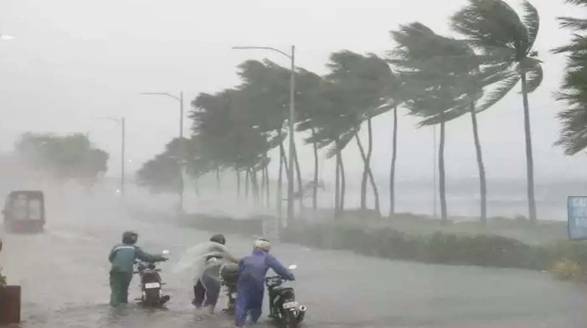
Warning of extremely heavy rain in Karnataka and Kerala
The Meteorological Department has issued a red alert for extremely heavy rainfall (>20 cm) in parts of Karnataka and Kerala on June 8 and 9. Along with this, there are chances of heavy rains in the northeastern states of Arunachal Pradesh, Assam, Meghalaya, Nagaland, Manipur, Mizoram and Tripura throughout the week (8-14 June). Continuous rainfall is also likely over Sub-Himalayan West Bengal and Sikkim, while extremely heavy rainfall is predicted over Assam, Meghalaya and Arunachal Pradesh between June 9 and 14.
Will get relief from scorching heat due to western disturbance
It is a matter of relief for the plains of North India that due to the new western disturbance, there will be rain with thunderstorms and strong winds in Delhi, Punjab, Haryana and Chandigarh between June 11 and 14. This will provide great relief to people from the torture of scorching heat and heat wave. There are favorable chances of rain in many areas of Rajasthan and Uttar Pradesh between June 10 and 14. At the same time, in hilly states like Himachal, Uttarakhand and Jammu and Kashmir, there is a warning of sporadic rain during June 8 to 14 along with hailstorm on June 11-12.
Clouds will be visible in Central, Eastern and Western India also
According to the IMD report, light to moderate scattered rain may occur in Chhattisgarh, Madhya Pradesh and Vidarbha during June 8 to 14. Heavy rain will continue throughout the week in Andaman and Nicobar Islands. The pace of rain is also expected to increase in Bihar, Jharkhand and Odisha between June 11 and 14. Talking about West India, there will be heavy rains in Konkan and Goa during June 8 to 10, while after that (June 11-14) there will be light showers. Areas of Central Maharashtra, Marathwada and Gujarat may also record light to moderate rain throughout this week.
Comments are closed.