
Ho Chi Minh City unveils underground metro stations to link all 3 Tan Son Nhat airport terminals

The Ho Chi Minh City Urban Railway Management Board, which manages all metro projects, recently submitted the proposals related to Metro Line No. 6 to local authorities for review before starting construction.
The line is intended to become the main rail link between Tan Son Nhat International Airport and eastern HCMC. Once connected to the Thu Thiem–Long Thanh Railway, it will create a high-capacity transport corridor between Tan Son Nhat and the upcoming Long Thanh International Airport and ease pressure on the road network.
The line is among the city’s priority infrastructure investments, with construction expected to begin by the end of this year and be completed by 2030.
According to the feasibility study, the line will stretch nearly 23 km, including about 19 km underground. It will have 13 underground and four other stations, and its depot will be in the former Thu Duc City’s Binh Trieu area.
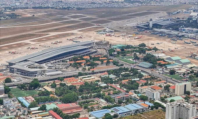
The area around Terminal 3 of HCMC’s Tan Son Nhat International Airport, where the underground station for Metro Line No.6 will be located. Photo by Read/Quynh Tran |
Changes have been made to original plans, with the route alignment and several station locations being adjusted to better integrate with surrounding infrastructure and optimize operations.
The line will begin at Ba Queo Station near the Tan Ky Tan Quy–Truong Chinh intersection, where it will connect with the Ben Thanh–Tham Luong line, or Line No.2, now under construction.
From there, it will head east and go beneath Tan Son Nhat airport.
There, station ST02 will be built west of T3, the new domestic terminal, in two levels.
The alignment through the airport has been straightened from the original plan, and the station has been moved closer to the passenger terminal to improve access.
It will combine two different stations that were in the original plan but only a kilometer apart and too far from T3 to walk conveniently.
The line will then continue underground toward the domestic terminal T1 and the international terminal T2.
ST03 Station is planned beneath the parking area between T1 and T2, near the Truong Son–Hong Ha flyover.
The station will form an interchange with Metro Line No. 4 (Dong Thanh–Hiep Phuoc Industrial Park) and have three levels.
ST02 and ST03 will allow passengers to reach Tan Son Nha airport entirely by metro and reduce reliance on road transport.
After leaving the airport, the line will go along Hong Ha Street, with ST04 Station coming up near the Nguyen Thai Son–Nguyen Kiem intersection.
It will continue along Pham Van Dong Boulevard, with stations located near the North–South Railway, the Phan Van Tri intersection, and Nguyen Xi Street.
It will then run beneath the Saigon River before returning to the Pham Van Dong corridor and heading toward Thu Duc.
At Vo Nguyen Giap Boulevard, ST12 Station will be an interchange, allowing passengers to switch to the Ben Thanh–Suoi Tien Metro Line, line No.1, currently the only operational metro line in the city.
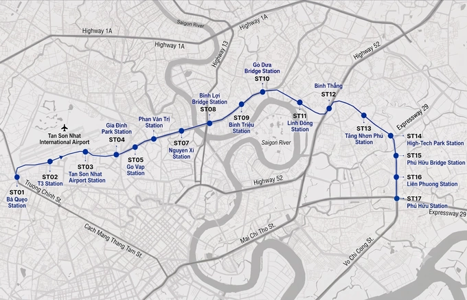 |
A map of Metro Line No.6. Graphic by Read/Tam Thao, Minh Nga |
From the Ring Road 2 area, the line will gradually move up to the surface, passing the Vo Chi Cong intersection, Phu Huu Bridge, and Lien Phuong Street.
Beyond ST16, the line will split into two, one terminating at ST17, the final station near Phu Huu Bridge, and the other connecting up with the Thu Thiem–Long Thanh Railway, the 47.7 km line that will link HCMC with Long Thanh airport.
Consultants have proposed adopting technical standards similar to those used for Metro Line No. 2.
Trains will operate at maximum speeds of 80–110 kph. The initial fleet will consist of three-car trains, with the option to expand to six as demand grows.
Comments are closed.