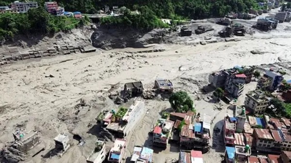
New Delhi. The sudden flood in Nepal on Wednesday morning caused huge damage in Rasuwa, Nuwakot, Dhading and Chitwan within a few hours. Many bridges were broken and power structures were also affected. It has come to light that the flood water is coming from the upper part of Lhende river near Tibet Border. Now the biggest question is where did so much water suddenly come into the river. Initial investigation has revealed three possible reasons for this, but no single reason has been confirmed yet.
Flood water reached Rasuwa district of Nepal at around 9 am on Wednesday morning. After this the strong flow spread to Nuwakot and Dhading. India Today's open-source intelligence (OSINT) team has collated the locations of three major flood-affected locations—Rasuwagadhi on the Tibet border, New Trishuli Bridge in Nuwakot and Malekhu Bridge in Dhading.
First theory: The river's path was blocked by debris.
The investigation has revealed the first possibility of snow, rocks and debris slipping from the mountain. It is feared that the flow of water stopped for some time due to a large amount of debris falling into the river. Water kept accumulating behind it and as the pressure increased the blockage broke. After this the accumulated water rapidly flowed towards the low-lying areas.
According to the Disaster Management Authority of Nepal, marks of sliding of snow and rocks have been found about 20 kilometers away from Rasuwagadhi. Satellite images also show a sudden increase in the spread of the river. However, on the basis of these photographs alone, it cannot be decided that the flood was caused by the bursting of the glacier lake.
Second theory: Not an earthquake, but vibration of landslide
Initially, tremors recorded in this area of Tibet shortly before the flood were linked to an earthquake. However, after the status update by USGS, the picture has changed. Analysis of seismic data and satellite images indicated that the tremor was caused by a landslide. In such a situation, the initial fear that earthquake was the cause of flood has weakened.
Third theory: Flood caused by bursting of glacial lake
The third and important possibility is GLOF i.e. Glacial Lake Outburst Flood. Sudden release of water from a snowy lake formed on the mountains can create a very strong downward flow.
According to Min Kumar Aryal, senior meteorologist of Nepal Meteorological Department, the flood in Bhotekoshi was not caused only by rain. He says that the rainfall in Rasuwa in the last 24 hours was not more than 7 mm. In such a situation, the possibility of the glacial lake bursting is also being investigated. At present, none of these three possibilities – debris slide, landslide and glacial lake bursting – has been considered as the final cause. The investigation is still going on.
Flood water can reach India
India's concern regarding this flood in Nepal has increased because the affected river system later takes the form of Gandak River in India. Trishuli river joins Kali Gandaki in Devghat to form Narayani. This river is called Gandak after reaching near Valmikinagar in India. For this reason, Indian agencies are keeping an eye on the water level of Gandak. The Central Water Commission has advised the areas situated on the banks of Gandak in Bihar and Uttar Pradesh to remain alert.
Surveillance increased in 6 districts of Bihar
Keeping in view the possible impact of flood, West Champaran, East Champaran, Gopalganj, Saran, Muzaffarpur and Vaishali of Bihar are being monitored. West Champaran is the first major Indian district to fall in the potential path of floods. NDRF teams have been deployed in Bettiah, Gopalganj and Muzaffarpur. Apart from this, SDRF teams are also present in sensitive areas.
Maharajganj-Kushinagar of UP also on alert
Maharajganj and Kushinagar districts of Uttar Pradesh have also been alerted due to the fear of rising water in Gandak. Gandak further joins Ganga near Hajipur and Sonpur. However, when water leaves the hilly areas and reaches the plains, the spread of the river increases and the speed of flow is likely to reduce.
No direct impact on other rivers
The course of Kosi, Bagmati, Budhi Gandak and Ghaghra rivers is different. Therefore, the flood water from Nepal does not directly reach these rivers. At present, the possible impact is said to be limited mainly to the areas along the path of Gandak River.
The maximum surveillance in India is on the stretch from Narayani to Valmikinagar and from there to North Bihar via Gandak. The real reason for the sudden flood in Nepal will become clear only after the investigation is completed, but the path for water to reach India is clear – from Nepal to Narayani, from Narayani to Gandak and then to Ganga.