
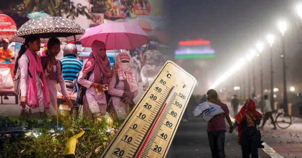
New Delhi. Dense fog continues to wreak havoc in North India. Most parts of Central and Eastern India are also covered with dense fog, especially in the morning and night. Also, due to continuously decreasing difference between minimum and maximum temperatures, melting has started increasing in the plains. The high peaks in the western Himalayan states are covered with a white blanket of snow. The mercury has reached below 10 degrees at at least nine places in Odisha. There is a possibility of light rain and snowfall in these areas for the next five days.
According to the latest data from the India Meteorological Department (IMD), dense fog was seen in parts of Punjab and Uttar Pradesh and visibility was less than 50 metres. Visibility remained zero in Punjab’s Amritsar and Uttar Pradesh’s Agra, Kanpur Air Force Station and Prayagraj Air Force Station. Dense fog also occurred at some places in Himachal Pradesh, Haryana, East Madhya Pradesh and North Chhattisgarh and visibility was less than 50 meters. At the same time, there was slightly more fog than normal in isolated areas of Odisha, Bihar, Uttarakhand, Tripura and Rajasthan and visibility was recorded between 50-200 meters.
Very dense fog is expected during night and morning hours in Punjab, Haryana, Chandigarh and Delhi till December 27. Dense fog may persist in some areas of Bihar, Odisha, Rajasthan, North Chhattisgarh, Jharkhand, North Madhya Pradesh and Northeast India for the next two to three days. Minimum temperatures over northwest India may fall between 3-5 degrees Celsius in a phased manner for the next three days. After the next 24 hours, the temperature in Central India may also drop by two degrees.
Jammu and Kashmir: Snowfall on the mountains for the second day in Chille Kalan.
Light snowfall occurred on the mountains in Kashmir on Monday, the second day of Chille Kalan. It remained cloudy in the plains. Bandipora-Gurez road closed since Saturday and Mughal road closed after snowfall on Sunday has not been opened yet. The Meteorological Department has predicted snowfall on Tuesday also. The weather is expected to remain like this till the new year and the cold will increase. Since the snowfall, the cold wind has left one shivering. There is a difference of only 5.5 degrees between day and night temperature in Srinagar. Due to very low day temperature, cold is being felt more. On Monday, the maximum temperature in Srinagar was recorded at 9.5 degrees Celsius, which is 0.5 degrees more than the normal. The minimum temperature was 4.0 degrees Celsius which is 6.4 degrees more than normal. According to the Meteorological Department, the valley will remain partly cloudy and partly cloudy at other places till December 31.
9 inches of snow fell in Gulmarg, tourist places buzzing with tourists
Snowfall in Kashmir Valley has covered the upper areas of the valley with a white sheet. These include the world famous tourist places of Kashmir like Sonamarg, Gulmarg, Dudhpathri, Daksum, Pahalgam etc. The snowfall till Monday morning has made these tourist places buzzing with tourists. Apart from about 9 inches in Gulmarg and 7 inches in Sonamarg, 4-5 inches of fresh snowfall was also recorded on the famous tourist spot of Pahalgam including Jade Gali, Machhil, Rajdhan Pass, Sadhna Top, Naugam sector and on the hills of Pir Panchal.
14 flights canceled in Delhi due to fog, 500 delayed
Air services have been worst hit by the dense fog prevailing in the national capital. On Monday, 14 flights were canceled while over 500 were delayed due to poor visibility due to dense fog at the Indira Gandhi International Airport. Officials said the canceled flights included six arriving and eight departing flights. There were also international flights among them. According to information available on flight tracking website flightradar24.com, more than 500 flights were delayed and the average delay time was a little over 30 minutes.
Comments are closed.