
Big update in Mappls app: Now complete information about metro, bus and train will be available on one app.
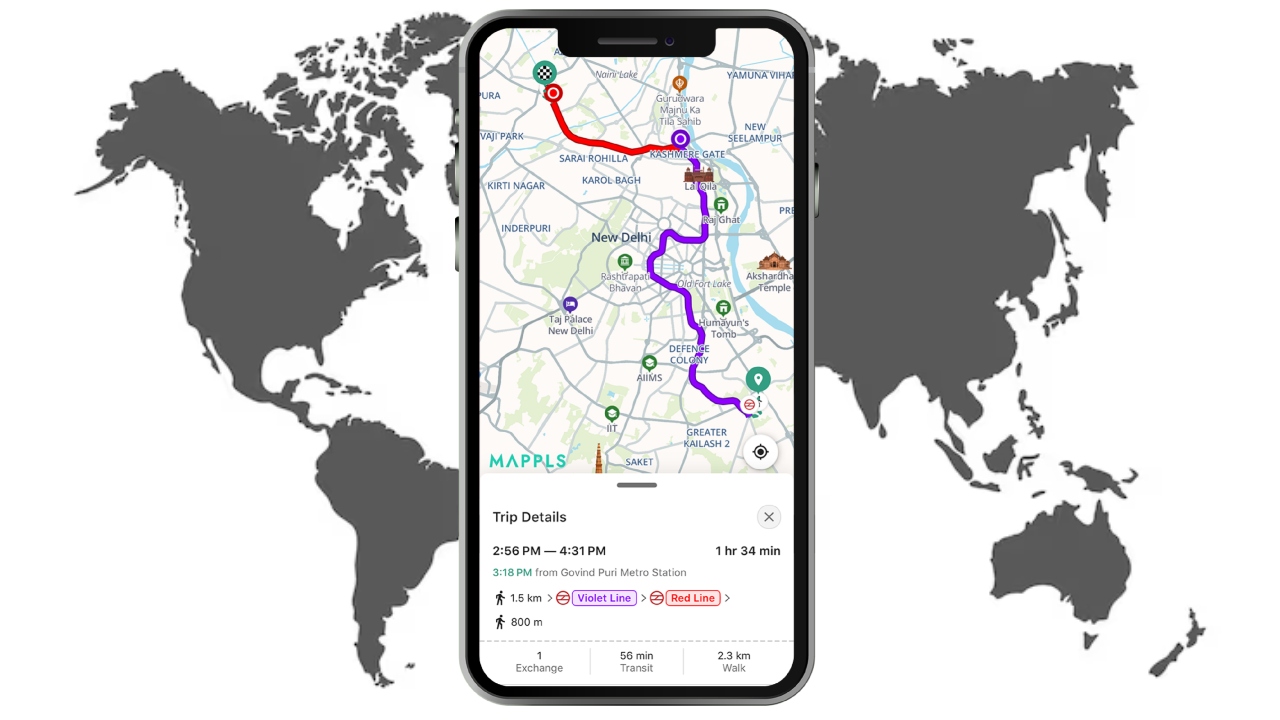
Public Transport Navigation MapmyIndia Mappls: India’s leading digital mapping, navigation and location-intelligence company MapmyIndia Maples has further strengthened the capabilities of its flagship Mappls App by adding multimodal public transport routing feature to it. After this new update, users will now be able to get information about metro, rail and bus routes directly within the app.
Private and public transport in one app
With this update, MapmyIndia Mappls further strengthens itself as a complete multimodal mobility platform, where navigation features for both private and public transport are available in a single, completely indigenous app. Serving over 40 million users, the Mappls App now shows travelers public transport routes, stations, stops and interchange points, making it easier to plan smart, affordable and sustainable journeys.
Facility started in these cities
Currently, this feature is live in major cities like Delhi, Mumbai, Bengaluru, Chennai, Hyderabad, Chandigarh, Pune, Kolkata, Ahmedabad, Nagpur, Indore, Patna, Lucknow, Kanpur, Agra, Jaipur, Kochi and Bhopal. This feature is currently available on iOS and web platforms, while it will be rolled out soon for Android users.
Updates related to user needs
Commenting on the launch, Rakesh Verma, co-founder, chairman and managing director of the company, said, “This new feature has been designed directly keeping in mind the needs of the users.”
He said the company aims to make the Mappls App more inclusive and accessible to everyday commuters, as well as make mass transit easier for millions of Indians by continuously expanding public transport coverage. He also added that this indigenous platform, made in India, made for India, is committed to promote sustainable urban mobility.
Existing features will be strengthened
The Public Transport Routing feature leverages Mappls’ existing features like turn-by-turn navigation, real-time traffic updates, safety alerts and intelligent route planning. The company believes that with this, people will use bus, metro and rail networks more, which will reduce traffic jams, reduce pollution and improve the environment of cities.
Also read: Government is strict on objectionable content: Warning to social media, if action is not taken then problems will increase
Technology in line with national priorities
MapmyIndia Mappls’ mapping and location technologies are developed entirely in India and comply with government guidelines regarding sensitive infrastructure and national boundaries. For this reason, the company has developed strong relations with government institutions and today about 20 percent of the company’s income comes from the public sector.
Public transport will be promoted in the new year
Amidst the increasing focus on sustainability in the new year, MapmyIndia is appealing to Mappls citizens to plan their daily journeys using public transport options through the Mappls App. The company will further improve the coverage and data in future in collaboration with transport authorities and partners.
Comments are closed.