
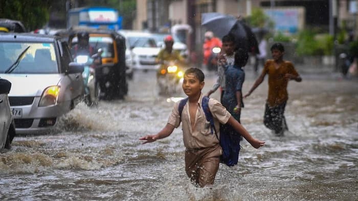
Mumbai Submerged: Lake Levels Surge Past 41% as Tulsi and Vihar Overflow, But Why Does the City Keep Flooding?:

The financial capital of India is once again bearing the brutal brunt of the southwest monsoon. Persistent torrential downpours over the past week have left nearly half of Mumbai battling severe waterlogging and structural disruptions. Tragically, the Brihanmumbai Municipal Corporation (BMC) has reported that at least 13 individuals have lost their lives in rain-related incidents since the onset of the season.
The Silver Lining: Seven Supply Reservoirs Log Drastic Water Stock Boost
While the relentless downpour has paralysed local streets, it has delivered a critical breakthrough for Mumbai’s looming water crisis. The seven catchment lakes responsible for supplying drinking water to the city have recorded a dramatic replenishment cycle.
The combined water stock across these reservoirs jumped from a worrying sub-10% capacity on July 4 to 41.43% of total live storage capacity by Thursday. Local authorities confirmed that Vihar Lake reached its maximum threshold first, followed closely by Tulsi Lake—the smallest reservoir located within city limits—which began overflowing. This early overflow is a massive improvement compared to the previous two years, when Tulsi Lake only hit full capacity in August.
Mumbai Reservoir Telemetry: Excess water spilling from the apex of Tulsi Lake flows naturally into Vihar Lake, forming an interconnected, automated supply corridor within the Sanjay Gandhi National Park network.
The Infrastructure Paradox: Why Upgrades Fail to Protect Mumbai
Despite the civic body spending billions of rupees annually on widening stormwater systems and installing high-capacity pumping stations, major transit hubs and residential zones transform into swimming pools every July. Urban planners and climate specialists point out that standard concrete modifications fail due to several structural and environmental bottlenecks:
Extreme Cloudburst Frequencies: The primary challenge is not the total volume of seasonal rainfall, but the compressed timeline in which it drops. Due to escalating climate change impacts along the West Coast, the city routinely experiences extreme precipitation events in which 150 mm to 300 mm of water falls within a tight window of three to four hours. Even advanced modern engineering setups cannot process that sheer volume instantaneously.
The Arabian Sea High-Tide Blockade: Mumbai’s unique coastal geography presents an unyielding physical constraint. The city’s massive stormwater drains rely entirely on gravity to discharge collected rainwater into the Arabian Sea. However, when heavy cloudbursts coincide with a high-tide cycle exceeding 4.5 meters, the sea acts as a literal wall, forcing the water back into the drainage channels and causing prolonged urban flooding.
The Elimination of Natural Safeguards: Rapid urbanisation and concrete expansion have stripped the metropolitan region of its indigenous natural flood buffers. Vast tracts of vital salt pans, open wetlands, and coastal mangrove forests have been systematically encroached upon for real estate development. Without permeable soil or active mangrove networks to absorb shock volumes, rainwater flows instantly onto paved roads and low-lying subways.
Outdated Blueprints and Plastic Choking: Significant portions of Mumbai’s subterranean drainage layout date back to the British colonial era, designed to handle a rainfall intensity of just 25 mm per hour. While the BRIMSTOWAD project sought to upgrade this capability to 50 mm per hour, it remains inadequate for modern weather realities. Furthermore, these critical networks are constantly throttled by institutional maintenance failures, as drains become choked with unmanaged plastic waste, mud, and heavy construction debris.

Comments are closed.