
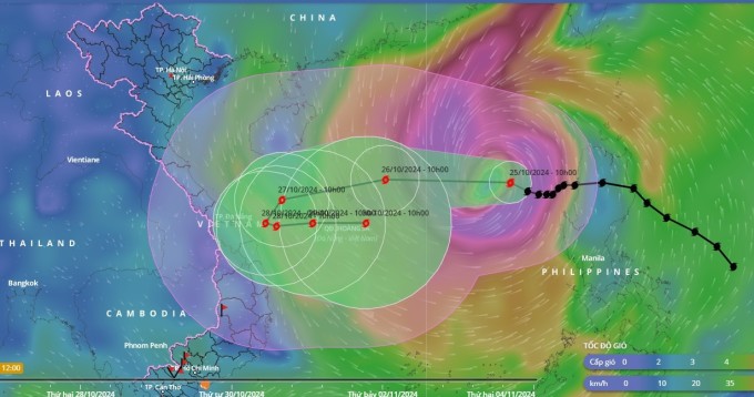
The predicted trajectory of storm Trami, showing it is likely to turn back to sea near Vietnam’s coast. Graphics by Vietnam Disasters Monitoring System
After entering Vietnamese waters on Thursday afternoon and gaining strength, Tropical Storm Trami is expected to turn back towards the sea on Sunday.
As of 10 a.m. on Friday, the storm lay centered over the eastern area of Vietnam’s East Sea, moving west-northwest at a speed of 20 kph, with maximum wind speeds reaching 102 kph, according to the National Center for Hydro-Meteorological Forecasting.
The center predicts that by 10 a.m. on Saturday, the storm will be positioned 160 km northeast of the Hoang Sa (Paracel Islands), moving west-southwest at a speed of 15 kph, with intensified winds reaching up to 133 kph.
The storm is then expected to slightly shift southward, heading towards Vietnam’s central coast, particularly in the vicinity of Da Nang City.
However, on Sunday, due to the influence of a cold air mass from the north and a newly formed storm off the coast of the Philippines, Trami is likely to make a 180-degree turn back out to sea.
The Japan Meteorological Agency has made a similar forecast, predicting that when Trami is about 100 km from Vietnam’s central coast, it will reverse direction and head back to sea, with wind speeds maintained at around 90 kph.
The Hong Kong Observatory shares this outlook, projecting that the storm will maintain wind speeds of 110 kph before changing direction.
Trami entered the East Sea on Thursday afternoon with maximum winds of 88 kph, marking the sixth storm in the region this year.
In the Philippines, heavy flooding and landslides triggered by Trami have resulted in at least 40 deaths as of Friday morning, with authorities working to rescue trapped villagers, according to AFP.
Comments are closed.