Typhoon Yinxing intensifies towards Vietnam’s coast
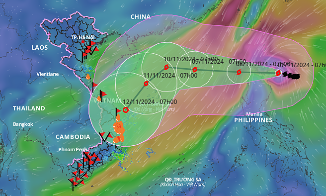
According to the National Center for Hydro-Meteorological Forecasting, as of 7 a.m. on Thursday, the typhoon’s center was northeast of Luzon, with wind speeds exceeding 160 kph and gusts above 200 kph—an increase of two levels since noon on Wednesday.
On Thursday morning, the storm was moving northwest at 5-10 kph, skimming past Luzon and entering the East Sea. By 7 a.m. on Friday, Yinxing’s center is expected to be positioned east of the northern East Sea, with maximum winds of 166 kph and gusts up to 201 kph.
As it enters Vietnam’ waters, the storm will accelerate to 15 kph, moving westward. By 7 a.m. on Saturday, Yinxing is projected to be approximately 430 km from the Paracel Islands, with maximum winds of 133 kph and gusts reaching 166 kph.
In the coming days, under the influence of cold air from the north, the storm is expected to shift southward at 15-20 kph, approaching the coast of central Vietnam by Tuesday next week.
Japan’s Meteorological Agency reported that Typhoon Yinxing is currently at its peak, with maximum winds of 180 kph, which it will maintain as it passes north of Luzon. The Hong Kong Observatory has classified Yinxing as a super typhoon, with winds of 195 kph. Both agencies predict the storm will enter the East Sea on Friday.
Six storms have entered Vietnam’s waters this year. The most recent, Typhoon Trami, made landfall in Thua Thien Hue and Da Nang on Oct. 27, bringing heavy rain to central Vietnam. The storm left eight dead, 14 injured, damaged nearly 330 houses, over 1,200 hectares of crops, and resulted in the loss or washing away of 1,500 livestock.
In September, the Institute of Meteorology, Hydrology, and Climate Change projected that four to five additional typhoons could enter the East Sea before the year’s end, with 2-3 potentially affecting mainland Vietnam.


Comments are closed.