
Monsoon Fury: IMD Sounds Highest Red Alert in Maharashtra as Relentless Rains Threaten Waterlogging and Landslides:
The southwest monsoon has taken a vigorous, aggressive turn over western India, triggering severe weather across the Konkan region and interior districts. Responding to an intensifying offshore trough and strong westerly wind surges from the Arabian Sea, the India Meteorological Department (IMD) has upgraded its warning system to a Red Alert—its highest level of weather advisory—for Central Maharashtra spanning July 3 to July 5. Authorities are warning of exceptionally heavy downpours that could cripple transit infrastructure, test urban drainage networks, and severely impact normal civic life over the weekend.
Extreme Deluge Forecast: What the 24-Hour Windows Hold
According to meteorologists, atmospheric conditions are primed to dump between 11.5 cm and 20.4 cm of rain within isolated 24-hour windows. The impact is expected to be most severe along the windward side of the Sahyadri mountain range.
The weather office has issued a strong advisory advising tourists, trekkers, and daily commuters to avoid visiting or travelling through the dangerous Ghat sections. With the active-to-vigorous phase of the monsoon rapidly saturating the soil, these fragile hilly terrains face heightened risks of sudden flash floods, severe mudslides, and unpredictable rockfalls that could completely block arterial highway passes.
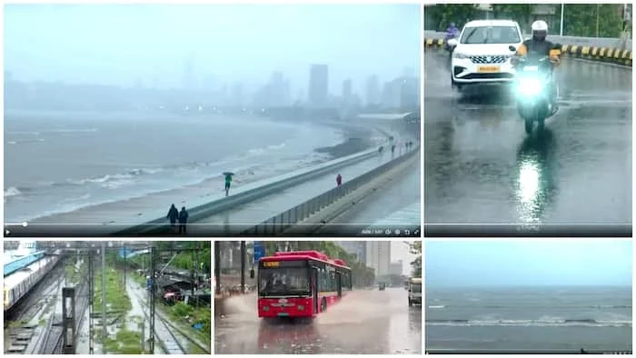
Mumbai Metropolitan Region Stays on High Alert Amid Infrastructure Strain
Closer to the coast, the Mumbai Metropolitan Region (MMR)—encompassing Mumbai, Thane, Palghar, and Raigad districts—continues to experience heavy showers. While parts of Mumbai and Thane are placed under an Orange Alert for heavy to very heavy localised rainfall, neighbouring Raigad remains tightly bound under the Red Alert zone.
Civic bodies like the Brihanmumbai Municipal Corporation (BMC) are actively monitoring low-lying urban flood spots, such as the Andheri subway, following a series of tree collapses, wall damage, and localised waterlogging incidents earlier in the week. While the intense downpours have successfully replenished the city’s crucial fresh-water reservoirs—raising lake levels significantly after a parched June—commuters are urged to closely check live railway and road traffic delays before stepping out.
Divergent Weather Dynamics: Light to Moderate Rain Bound for Pune City
Interestingly, the leeward side of the mountain range will experience a completely different version of this weather system. While the rural Ghat sections of Pune district are bracing for torrential extreme spells, Pune city itself—including core pockets like Shivajinagar and Lohegaon—is expected to see a much milder response.
The city is forecast to see mostly light to moderate rain showers, accompanied by isolated, low-intensity thunderstorms, over the next three to four days. Temperatures in Pune are projected to remain pleasant, hovering around 27°C during the day with comfortable evening minimums near 22°C, offering urban residents a cool relief without the destructive urban flooding risks plaguing the coastal belts.
Comments are closed.