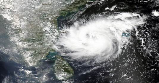
The fear of another cyclonic storm forming in the Bay of Bengal has increased the concern of the coastal states. According to the Indian Meteorological Department (IMD), the deep pressure area formed in the south-eastern Bay of Bengal is moving rapidly. It is likely to take the form of a cyclonic storm on November 16 and turn into a severe cyclonic storm by November 17. After this, it may move further in the north-west direction towards the Andhra Pradesh coast.
The name of this possible storm will be 'Akwan'. This name has been given by Iran. The Meteorological Department is constantly monitoring its direction, speed and intensity.
Possibility of becoming a cyclonic storm on November 16
According to the IMD's November 15 bulletin, at 5:30 am on Sunday, the weather system was centered over southeast and adjoining southwest Bay of Bengal. It is likely to move in a north-westerly direction and become a cyclonic storm over south-central and adjoining west-central Bay of Bengal on 16 November. It is expected to turn into a severe cyclonic storm on November 17.
Heavy rain forecast in Andhra Pradesh, Tamil Nadu and Odisha
The Meteorological Department has warned of heavy rain in many states due to the impact of the possible storm. Coastal Andhra Pradesh and Yanam may receive heavy to very heavy rainfall at isolated places and extremely heavy rainfall at isolated places during 19 to 20 November. There is a possibility of heavy to very heavy rain in Tamil Nadu on 18 and 19 November. At the same time, heavy to very heavy rain may occur in some areas in Odisha between November 19 and 21.
As the storm progresses, there is a possibility of increased sea turbulence. In such a situation, fishermen and people going to sea have been advised to pay attention to the warnings of the Meteorological Department.
Where will landfall occur? The picture is not clear yet
The Meteorological Department has not yet declared the exact location of this cyclone hitting the coast. Some weather forecasts have predicted it to move towards the Andhra Pradesh coast, while private weather analysts have also noted coastal areas of northern Tamil Nadu and southern Andhra Pradesh. However, the claim of hitting the coast on the night of 19 November or the morning of 20 November is not yet officially confirmed.
According to meteorologists, as the system progresses, the situation regarding its direction and possible landfall area will become more clear. Therefore, it is too early to name any one coastal city or place as the definite landfall center of the storm.
Effect of rain and fog in North India also
Apart from this system in the Bay of Bengal, there is a possibility of light rain at some places on November 15 due to the influence of Western Disturbance in North-West India. Scattered rain may occur in parts of Western Uttar Pradesh, Haryana, Delhi, Punjab and Rajasthan. Dense to very dense fog conditions have also been recorded in some areas of Uttar Pradesh.
The monitoring of the weather department continues. The new bulletin to be issued in the coming days is expected to provide more clear information about the cyclone's strength, direction and its possible impact on the coastal states.