
Dr. Truong Ba Kien, deputy executive director of the Vietnam Institute of Meteorology, Hydrology and Climate Change’s Center for Meteorology and Climatology, speaks to Read about the likelihood of El Niño and its potential impacts on Vietnam.
Dr. Truong Ba Kien, deputy executive director of the Vietnam Institute of Meteorology, Hydrology and Climate Change’s Center for Meteorology and Climatology. Photo by Read/Gia Chinh |
International meteorological agencies have warned of a possible “super El Niño” this year. What is your take on this?
First, in climatology there is no term such as “super El Niño” or “super La Niña.” These are media-driven labels used to describe exceptionally strong El Niño events.
El Niño’s intensity is measured using the Oceanic Niño Index (ONI), defined as the three-month running mean of sea surface temperature anomalies in the Niño 3.4 region of the central equatorial Pacific. Based on this index, El Niño events are classified as weak (0.5-0.9 C), moderate (1.0-1.4 C), strong (1.5-1.9 C), and very strong (2.0 C or higher).
In that sense, a “super El Niño” effectively refers to a very strong event with ONI exceeding 2.0 C.
Updates from major forecasting centers such as the U.S. National Oceanic and Atmospheric Administration (NOAA) and the European Centre for Medium-Range Weather Forecasts indicate a greater than 60% probability of a transition to El Niño in summer 2026, potentially lasting through the end of the year. The likelihood of reaching very strong intensity by year-end is estimated at around 25%. However, model projections still diverge on peak intensity and require further monitoring.
Overall, confidence in the formation of El Niño is relatively high, given clear oceanic signals and favorable atmospheric conditions for warming. However, uncertainty remains significant regarding peak intensity due to the ENSO “spring predictability barrier,” a period when forecast skill declines and model spread widens.
If there is indeed a very strong El Niño event, how would you assess its likely impact compared to those in 1997-1998 and 2015-2016?
Such comparisons should be treated with caution.
Similar ONI values or classification levels do not imply identical climate impacts. ENSO effects depend not only on temperature anomalies in the Niño 3.4 region but also on the spatial structure of sea surface temperature anomalies across the tropical Pacific, the timing of peak intensity, the coupling between oceanic and atmospheric systems, and the concurrent state of other climate oscillations.
A temperature anomaly is the difference between the current temperature and the long-term average.
Moreover, under climate change, the relationship between ENSO intensity and extreme weather is not linear. Extremes result from the interaction of natural variability, risk management capacity based on seasonal forecasts and a warming climate with higher humidity and altered thermodynamic conditions. Therefore, even with the same ONI level, impacts on heatwaves, drought, heavy rainfall, or storms can vary significantly across regions and periods.
In short, while intensity may approach historical extremes, impacts cannot be assumed to replicate past scenarios.
 |
The ground cracks amid drought in Vietnam’s Central Highlands in 2024. Photo by Read/Duc Hoa |
How does El Niño affect the global climate?
Fundamentally, El Niño alters the east-west sea surface temperature gradient across the equatorial Pacific, weakening the contrast between the western and eastern regions.
This disrupts tropical convection and the Walker circulation [a large-scale, east-west atmospheric circulation across the tropical Pacific Ocean, characterized by easterly trade winds at the surface and westerly flow aloft, as defined by the NOAA].
As the Walker circulation weakens or shifts, zones of convection and heavy rainfall move accordingly, triggering adjustments in subtropical jet streams and planetary-scale atmospheric waves. This mechanism leads to shifts in the location and timing of weather patterns globally.
However, El Niño impacts are not uniform across regions. They depend on the structure of warm water anomalies, timing of peak intensity, interactions with other climate systems, as well as local geographic and atmospheric circulation factors.
What impacts could El Niño have on Vietnam in terms of heat, rainfall, storms, and extreme events?
In Vietnam, El Niño is typically associated with above-average temperatures, increased evaporation, and reduced rainfall during certain periods, raising the risk of heatwaves, droughts, water shortages, and reduced river flows. However, impacts vary by region.
Rainfall deficits and droughts are often more pronounced in central and southern Vietnam and the Central Highlands, while the north tends to experience higher baseline temperatures and more frequent heatwave days. Current forecasts suggest average temperatures could be 0.5-1 C above normal, with more frequent and intense heat episodes.
During El Niño years, the number of storms and tropical depressions in the East Sea tends to be lower than the long-term average. However, this does not necessarily reduce risk, as strong storms, rapid intensification or erratic tracks can still occur. El Niño also does not preclude extreme events such as severe thunderstorms, tornadoes, lightning or hail during transitional seasons.
In other words, El Niño primarily shifts seasonal climate probabilities rather than determining specific weather events.
In the context of rising global temperatures, how could El Niño intensify heatwaves and climate risks in Vietnam?
El Niño is developing against a backdrop of markedly warmer global conditions in recent years. If it strengthens, it could amplify already elevated temperatures, increasing the likelihood of more intense and prolonged heatwaves.
It is not possible to attribute a specific temperature increase solely to El Niño, as heat intensity is influenced by multiple factors, including atmospheric circulation, the western low-pressure heat system, foehn winds, humidity, and intra-seasonal variability.
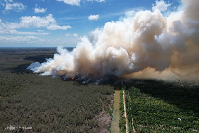 |
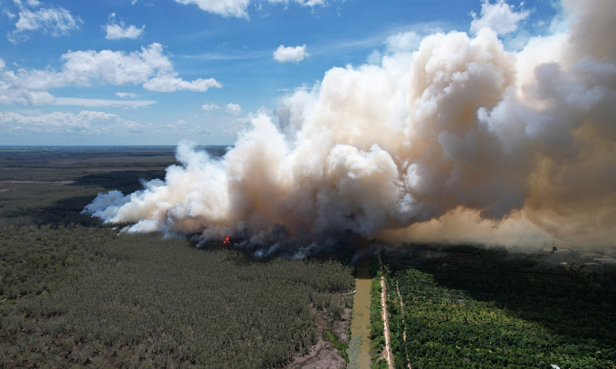
Fire erupts in Tram Chim National Park in Vietnam’s Mekong Delta amid strong heat in 2024. Photo by Read/Ngoc Tai |
What is clearer is that El Niño raises the probability of above-average temperatures, while climate change elevates the baseline. When these two forces interact, heatwaves tend to become more severe, longer-lasting, and more impactful.
If El Niño develops during the summer and intensifies toward the end of the year, risks will vary by season. In the summer and early autumn of 2026, key threats include widespread heatwaves, surging electricity demand, and localized water shortages. particularly in northern and central regions. From late summer into the 2026-2027 dry season, risks are expected to escalate in central, Central Highlands, and southern regions, including reduced rainfall, declining river flows, drought, and saltwater intrusion.
What should be done to minimize the impacts of El Niño?
An effective response to El Niño requires moving beyond single-scenario planning for heat and drought toward a multi-risk framework.
In agriculture, this includes adjusting cropping calendars, diversifying crop structures, and adopting water-efficient irrigation practices. In water resource management, authorities should closely monitor water balances, store water early, and prepare contingency supply plans. In the energy sector, planning must account for dual pressures: rising electricity demand due to heat and reduced hydropower output caused by water shortages.
At the local level, authorities should prepare simultaneously for heatwaves, forest fires, and water scarcity, while remaining vigilant against severe thunderstorms, hail, localized heavy rainfall, and complex storm systems. The most effective approach is risk management based on multi-timescale climate forecasts, with continuous updates as ENSO evolves beyond the spring predictability barrier in the coming months.
Comments are closed.