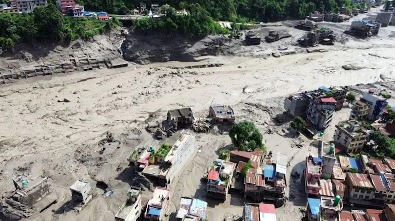
A major water crisis has arisen in the Himalayan region after a powerful earthquake of 5.1 magnitude in Tibet, an autonomous region of China. There have been reports of damage and breakage of a water storage dam located in the upper mountainous part of Tibet due to earthquake tremors. As a result, rapid flow of large amounts of water has started towards the low-lying plains and valley areas. The direct and most fatal impact of this deluge has fallen on the coastal areas of Nepal's main river Trishuli. Taking immediate action, Nepal's Ministry of Home Affairs and Department of Hydrology and Meteorology have issued a high alert in the entire Trishuli river basin including Rasuwa, Nuwakot, Dhading and Chitwan districts. In view of the rising water level of the river and the danger of water entering the settlements along the banks, the local administration has instructed people to move to safe higher places, after which an atmosphere of chaos has been created in the villages and towns situated on the banks of the river. The situation worsened due to the breaking of the dam in Tibet and the spate of rivers. The epicenter of the earthquake was recorded in the southern mountainous region of Tibet, the depth of which was about 10 kilometers below the ground. A shock of this intensity caused massive landslides on the mountain slopes and caused severe damage to natural and artificial water structures. The water flow became uncontrolled due to the breach of the dam wall following the sudden accumulation of huge amounts of debris and water in the tributaries originating from the Tibet region. The Trishuli River, which originates from Tibet and enters Nepal, is carrying with it heavy silt, stones and debris. The water level near Rasuwagadhi border is flowing several meters above normal. Temporary bridges, roads and coastal constructions built on the river banks have been submerged. According to local eyewitnesses, seeing the strong sound and flow of water, people are leaving their properties and houses and running towards safe places. Scramble and evacuation operations in coastal areas of Nepal The Government of Nepal has deployed special disaster response teams of the Army, Armed Police Forces (APF) and Nepal Police in sensitive areas. Warnings are being issued through loudspeakers in low-lying areas of Rasuwa and Nuwakot. The administration has taken the following major security measures: Evacuation of coastal settlements: Hundreds of families settled along the banks of Trishuli river are being shifted to community centres, schools and higher safe places with immediate effect. Restrictions on traffic and hydropower projects: Coastal routes on the Rasuwa-Kathmandu highway have been closed for security reasons. Operations of all ongoing hydropower projects on the Trishuli Basin have been temporarily halted to avoid damage to turbines and infrastructure. Relief and emergency shelter: Food, clean drinking water and first aid facilities are being provided to displaced civilians. Possible impact on the border areas of India (Bihar and UP) Trishuli River joins Kali Gandaki near Devghat in Chitwan district of Nepal to form 'Narayani River', which further enters Bihar state of India and is called 'Gandak River'. This flood in Tibet and Nepal is likely to have a direct impact on the border districts of India. Administrative officials of West Champaran (Valmiki Nagar Barrage), East Champaran, Gopalganj and Saran districts of Bihar have been alerted. The water level of Valmiki Nagar Gandak Barrage is being monitored 24 hours so that in case of sudden release of heavy water from Nepal, the danger of possible flood can be avoided by controlling the gates of the barrage. The State Disaster Management Department has kept NDRF and SDRF teams on standby mode. Geologists and environmental experts believe that due to the continuous collision of the Indian Plate and the Eurasian Plate, the Himalayan region comes among the most sensitive seismic zones in the world (Seismic Zone V). Whenever an earthquake of moderate to strong intensity occurs in this region, not only structural damage occurs, but the risk of blockage of mountain rivers, bursting of glacial lakes (GLOF) and dam breakage increases manifold. Experts say that due to climate change and uncontrolled construction work on the mountains, the natural balance has already weakened. In such a situation, seismic shocks put huge pressure on natural water structures. The need to further strengthen real-time hydrological data sharing and disaster early warning system between Tibet and Nepal has been felt for a long time. Important guidelines for citizens in case of emergency: Local administration and disaster management agencies have appealed to citizens not to pay attention to rumors and follow official information. Key safety protocols for residents of coastal and affected areas: Completely avoid going near river banks, ghats and low bridges. Always keep your necessary documents, medicines and emergency kit ready. Get in touch with local administration or disaster management helpline numbers. Do not go too close if the water level in the river appears to drop suddenly, as this may be a sign of a temporary dam formed by a landslide in the upper reaches which may break at any time. Water resources departments of Nepal and India are continuously monitoring the water situation and satellite imagery of Tibet so that every possible threat can be dealt with till the situation becomes normal.