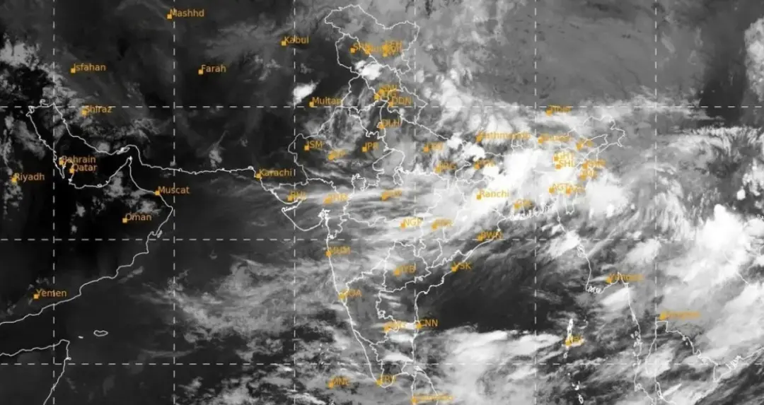
The phase of departure of monsoon is about to begin in India, but in the meantime, a recent picture taken from ISRO's weather satellite INSAT-3DS has revealed new information about the weather condition of the country.
New Delhi: The south-west monsoon is slowly moving towards withdrawal in India. Meanwhile, a recent satellite image from the weather satellite INSAT-3DS of the Indian Space Research Organization (ISRO) has shown a big difference between the weather in different parts of the country. In the picture, a large part of India is seen covered with dense clouds, while the sky is relatively clear in the north-western and western regions.
This picture taken from space shows that the withdrawal of monsoon does not happen in a uniform manner. While the weather looks relatively dry over northwestern parts including Rajasthan, Punjab and Gujarat, cloud activity continues over many areas of central, eastern and southern India.
Dense clouds cover from Bay of Bengal to Northeast
INSAT-3DS image shows a large cluster of clouds around the Bay of Bengal. These clouds are seen spreading towards eastern and north-eastern India. Different bands of clouds can also be seen in the southern peninsula and its surrounding sea area. Meteorologically, weather systems forming in the Bay of Bengal region can affect rainfall over eastern, central and southern parts of India. Moisture coming from the ocean, changes in atmospheric pressure and active weather systems can cause such wide expansion of clouds.
However, it is not appropriate to accurately identify a particular weather system or conclude its full impact based on satellite imagery alone. For this, it is necessary to look at other data of the Meteorological Department, ground observations and atmospheric conditions.
Image taken from 10.83 micrometer channel
INSAT-3DS is a meteorological satellite, used for meteorological monitoring. Such satellites play an important role in monitoring clouds, temperature and atmospheric activities. It has been told that the picture has been obtained from thermal infrared channel with 10.83 micrometer wavelength.
With the help of this technique, thermal information related to the earth's surface and clouds is obtained. Apart from India, the condition of clouds present in the surrounding areas can also be seen in the picture.
The difference was clearly visible in western India
The most striking aspect of the satellite image is the visible differences between different parts of India. Large areas of western and north-western India appear almost cloud free. Relatively clear skies over areas like Rajasthan, Gujarat and Punjab coincide with signs of withdrawal of monsoon. On the contrary, the presence of clouds over eastern and central India suggests that monsoon moisture and meteorological activities have not completely ended yet. This is the reason why the weather patterns are quite different at the same time in different parts of the country.
Deep depression increased rain activity
A weakening deep depression is also affecting the weather over eastern and central India during this weather pattern. Such systems can create moisture and instability in their surrounding atmosphere, leading to increased rainfall activity over some areas. As the weather system weakens, its impact may gradually diminish. However, its remnants and moisture may affect rainfall in the surrounding areas for some time.