
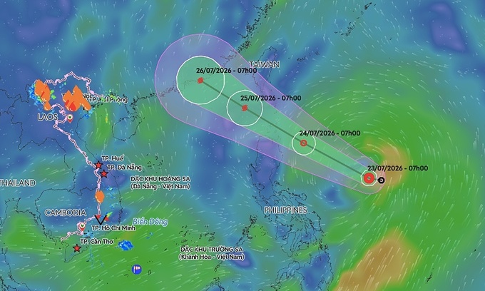

Vietnam’s National Center for Hydro-Meteorological Forecasting reported that as of 1 p.m. on Thursday, the depression lay centered over waters east of the Philippines. The system is packing maximum sustained winds of 50-61 kph, with gusts reaching up to 75-88 kph, and is moving at a forward speed of about 25 kph.
By 1 p.m. on Friday, the depression is expected to be positioned roughly 100 km east of Luzon Island in the Philippines. Forecasters anticipate its forward speed will remain at 25 kph. Its winds are expected to strengthen to 61-74 kph, with gusts up to 89-102 kph, at which point it is likely to develop into a tropical storm.
A predicted trajectory of a tropical depression in the East Sea. Graphic by Vietnam Disaster Monitoring System |
By 1 p.m. on July 25, the storm’s center is projected to hover over the northeastern waters of the northern East Sea. Maximum winds are expected to intensify to 89-117 kph, with dangerous gusts reaching up to 134-149 kph.
Both the Japan Meteorological Agency and the Hong Kong Observatory agree that the depression will intensify into a storm on July 24 before entering the East Sea. However, current projections indicate the system is unlikely to directly affect mainland Vietnam.
Since the beginning of the year, the East Sea has recorded one tropical depression and one storm.
Storm Maysak, which struck in early July, caused no fatalities but left significant property damage in its wake. The storm damaged 96 houses and swept away or sank 13 boats and rafts. It also battered approximately 1,100 hectares of aquaculture areas, resulting in estimated financial losses of VND20 billion (US$765,000).
Following Maysak, Super Typhoon Ba Vi lingered over the northwestern Pacific. While it generated strong winds and high waves across many Vietnamese maritime areas, it ultimately did not cross into the East Sea.
Since mid-July, northern Vietnam has endured repeated episodes of heavy rainfall. These relentless downpours have triggered flash floods and landslides, causing severe damage across several mountainous provinces.
Meteorological authorities project that the total number of storms and tropical depressions in the East Sea this year will be close to or below the long-term average. However, their intensity and precise tracking could prove difficult to predict during the peak storm season from July to September. Extreme rainfall, flash floods, and landslides remain major risks, particularly in the northern mountainous areas and central Vietnam.
Looking ahead at the specific weather forecast for the coming days, the national forecasting center said the northern region is bracing for moderate to heavy thunderstorms from the evening of July 23 through the night of July 24.
Forecasters predict general rainfall totals between 40 and 120 mm during this window, though some heavily impacted areas could endure extreme downpours exceeding 250 mm.
Authorities have issued specific warnings for a high risk of localized areas receiving over 100 mm of rain within three hours. This sudden deluge could overwhelm local drainage systems and trigger flash flooding.
This intense weather system will also extend southward into Thanh Hoa by the evening of July 24. Rainfall totals of 25 to 50 mm are predicted for the central province, although some areas could see precipitation surpass 100 mm.
While the intensity is expected to ease slightly by July 25, wet conditions will persist across both northern Vietnam and Thanh Hoa. Additional rainfall of 10 to 30 mm is anticipated throughout the day, with some locations still at risk of receiving more than 80 mm.
From the evening of July 23 to July 25, total rainfall across northern Vietnam is projected to reach between 70 and 150 mm. The most severely impacted areas could record cumulative totals surpassing 300 mm.
Further south, weather patterns remain unsettled. The Central Highlands and southern Vietnam are also forecast to experience sustained periods of moderate rain during this timeframe. Precipitation in these regions is expected to range from 20 to 50 mm generally, with localized pockets bracing for heavy to very heavy rainfall exceeding 100 mm.
Comments are closed.