The world map not only shows the location of countries and continents, it also decides how we see the shape of the world. For years, after seeing the map in schools, children have been considering Greenland as almost equal to Africa and Europe as much bigger than Africa, now efforts are being made to change that picture. The United Nations General Assembly has supported a proposal to adopt a world map in which Africa appears to be a much larger size than its actual area.
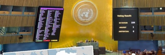
In the voting held on Friday, 164 countries voted in favor of the resolution, while the US opposed it and six countries abstained. The purpose of the proposal is to “more accurately represent” the shapes of the continents. For this, member countries have been urged to adopt equal-area maps like ‘Equal Earth Cartographic Projection’ instead of the traditional Mercator Projection.
1. What is there in the map that makes Africa appear bigger?
Actually, the earth is round, but the map is flat. This is the reason that while placing the globe on two-dimensional paper or screen, the size, distance or direction of some part has to be changed. The traditional Mercator projection placed more emphasis on accurately displaying directions and angles, as it was originally designed for maritime navigation. But one major effect of this was that the areas around the equator appeared relatively small and the areas at the northern-southern ends appeared relatively larger.
This is why on the Mercator map, Europe and North America appear larger than their actual area, while Africa and South America appear smaller. In the new ‘Equal Earth’ projection, the relative areas of land parts are kept more accurate. So Africa now appears larger in proportion than it actually is on the globe.
2. What is Mercator Projection and why was it created?
The Mercator projection was created by the Flemish cartographer Gerardus Mercator in 1569. Its purpose was not to show the actual area of the world’s continents, but to usefully maintain directions and angles during sea voyages.
This characteristic of this projection made it useful in maritime navigation for centuries. Therefore, it would not be correct to say that the Mercator map was “wrong”. The problem is that maps useful for navigation began to be used to compare the size of the world.
For example, in the Mercator projection, Greenland appears almost equal to Africa, whereas in reality the area of Africa is many times more than that of Greenland. Similarly, many areas of the Northern Hemisphere appear much larger than their actual size.
3. What is the ‘Equal Earth’ projection and who made it?
‘Equal Earth Projection’ was launched by a group of cartographers in 2018. Its basic purpose is to show the relative surface area of different parts of the Earth more accurately.
In this map, Africa, Latin America, South Asia and Oceania appear larger than in the Mercator projection, while North America and Europe appear smaller.
AFP quoted a 2025 statement from Bojan Savaric, one of the creators of this map, as saying that ‘Equal Earth’ maintains the relative surface area of the continents and, as far as possible, shows their size as they appear on the globe.
That is, the purpose of the new map is not to change the world, but to make our picture of the world more realistic.
4. What was Togo’s role in the resolution accepted by the UN?
This proposal was presented by Togo’s Foreign Minister Robert Dussey. His argument was that maps are not just a medium for giving geographical information. They influence education, shape our imagination, and shape our collective view of the world.
Ducey said that’s why maps are never completely neutral. If they present an inaccurate picture of the world, this misinformation can be passed down through generations.
Based on this thinking, it has been said in the proposal that ‘Equal Earth Cartographic Projection’ improves the accuracy of the way the world map is shown. The resolution urges Member States to widely adopt equal-area projections in education, public communications and other areas where comparison to actual landmass is important.
164 countries supported the proposal in voting. America voted against it, while six other countries abstained.
5. Why did America protest?
America strongly criticized this initiative. Before the vote, US representative Yaryna Ferencevich said that instead of focusing on the real problems, the UN body was debating 16th-century maps and their role in promoting reparations and “cognitive justice”.
The American side saw such initiatives in the context of questioning the priorities of the United Nations and said that due to such steps the organization is losing its credibility.
Despite this, America’s opposition is not proof that the Mercator projection is more geographically accurate. Mercator has its own utility, especially in maritime navigation. The controversy centers primarily on how the world should be depicted in general education and public communication and whether old maps inadvertently create misconceptions about the world’s size.
6. Why did France and African countries consider it so important?
France has also co-sponsored the resolution in support of the new map. France announced on Friday that it would stop using the Mercator projection.
French Foreign Minister Jean-Noel Barrot said that in the old map, the size of America, Russia and China appears much larger and more prominent than Africa, Latin America and South-East Asia. He specifically said that in this Greenland appears almost as big as Africa, whereas the reality is completely different.
Barrot also said that changing maps obviously does not change the world, but correcting a wrongly shown map is like revealing the truth.
This decision also has a political context. France comes at a time when it is trying to improve its relations with Africa, especially with former French colonies where relations have been strained in recent years. Therefore, this initiative is being seen not just as a matter of cartography, but also in the context of a broader discussion related to education, representation and the legacy of colonialism.
7. Will all the maps of the world change now?
It’s not like that. This resolution of the United Nations General Assembly is not legally binding. This means that it does not ban the Mercator projection nor force countries, schools, publishers or technology companies to change their maps.
The emphasis of the proposal is to encourage the widespread adoption of ‘Equal Earth’ and other equal-area projections, especially in education, public communications and in areas where comparison of the actual area of continents or countries is important.
Additionally, this proposal does not seek to remove the Mercator projection from maritime or air navigation. It is still useful in some navigational uses today due to its ability to maintain direction and angles.
Now the real challenge ahead is not to change the map, but to adopt it. Togo plans to replace the Mercator projection with a new projection in the geography curriculum of its schools by the end of the year. It will also encourage other governments, schools, international organizations and technology companies to adopt ‘Equal Earth’. Togo plans to spend the next six months in talks with African Union members and supporters in other regions to develop a strategy for widespread adoption.
France has also announced to abandon the Mercator projection. But the support of 164 countries in the UN does not mean that from the next day the shape of Africa will change on Google Maps, school books or every digital and print map of the world. Its actual impact will depend on which projection schools, publishers, international institutions and digital mapping platforms choose to adopt.
The map will change, not the world
The most interesting aspect of this whole debate is that Africa has not actually grown bigger – it has merely appeared on the map closer to its actual size. The shape of the Earth was always the same. The only difference is the perspective from which we see it on paper or screen.