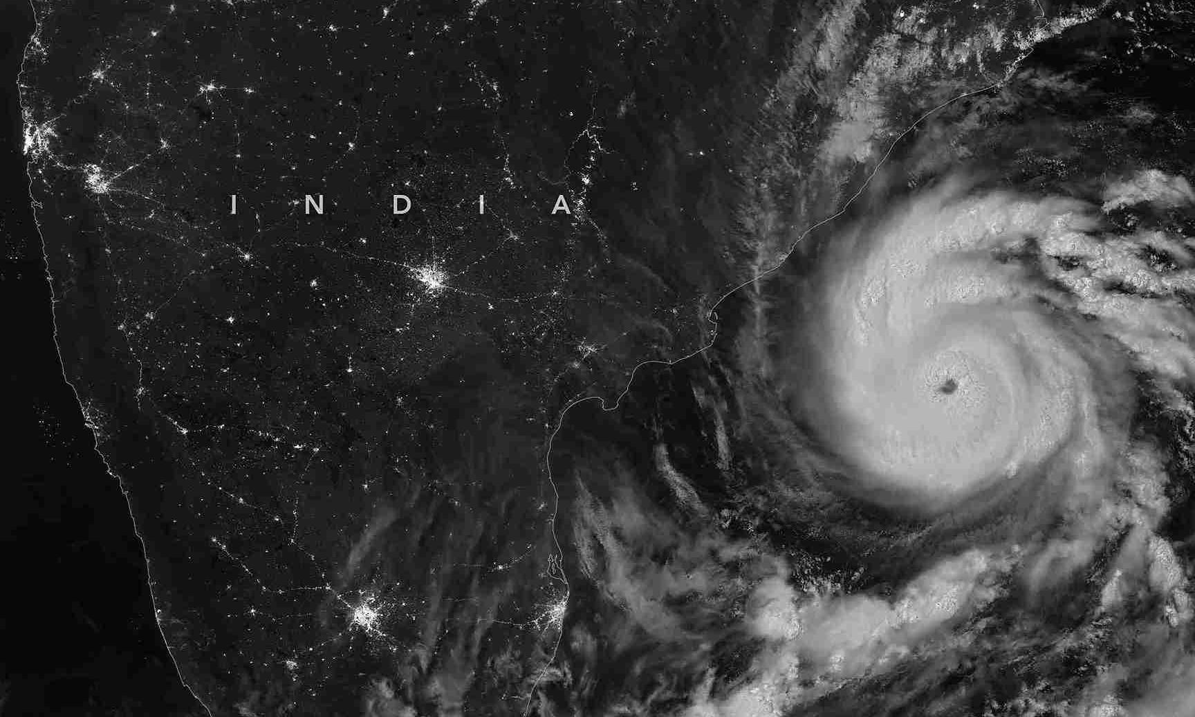
On Wednesday (October 28), severe cyclonic storm Arnab bruised Andhra Pradesh and Odisha with wind speeds of 150 kmph at landfall. In less than a week, another severe cyclonic storm, Murasu, is set to cross the Andhra coast during the intervening night of Monday and Tuesday (November 2-3). The distance between the landfall areas of the two cyclones is about 268 km in a straight line.
Not only Andhra but northern Tamil Nadu and Odisha will also be on high alert tonight. In Odisha, Cyclone Arnab claimed six lives in a landslide, and even on Monday, a search operation was underway to trace 10 more people who went missing after a rain-triggered landslide struck a village bordering Ganjam and Kandhamal districts.
Coastal Andhra Pradesh, of course, is still severely flooded from Cyclone Arnab. Preliminary estimates peg the losses at around Rs 4,700 crore across 12 districts, with Konaseema, West Godavari, and Srikakulam bearing the brunt of the devastation. And before it could even come to terms with the devastation, the state is bracing for the second impact: Cyclone Murasu.
Bay no stranger to cyclones but back-to-back severe storms?
So, how common is such a back-to-back severe cyclone event in the Bay of Bengal? The Bay is no stranger to destructive cyclones, but the rapid succession of two severe cyclonic storms within a week of each other has generated curiosity among meteorologists.
Also read: Cyclone Murasu: NDRF teams rushed to Andhra; over 20 flights cancelled
While the Bay of Bengal routinely generates powerful storms during the post-monsoon season, the formation of two severe cyclones in such quick succession is a rare event that requires a near-perfect alignment of oceanic and atmospheric conditions.
And that leads us to the broader question: Are warming oceans influencing cyclone behaviour?
One of the best-known precedents of back-to-back severe cyclones occurred in October 1999, when a severe cyclonic storm formed over the Bay and was followed within days by the devastating Odisha Super Cyclone, one of the most intense tropical cyclones ever recorded in the North Indian Ocean and one of the deadliest disasters in India’s history.
How unusual is the Arnab-Murasu sequence?
The development of two severe cyclones over the Bay of Bengal within a week is an exceptionally rare event. While multiple cyclones can occur in the same season, having two systems intensify into severe cyclonic storms in such a short window is far less common because cyclones typically disrupt the atmospheric conditions needed for another major storm to emerge immediately afterwards.
Historical records dating back to 1891 show only a handful of comparable episodes. One of the best-known precedents occurred in October 1999, when a severe cyclonic storm formed over the Bay and was followed within days by the devastating Odisha Super Cyclone, one of the most intense tropical cyclones ever recorded in the North Indian Ocean and one of the deadliest disasters in India’s history.
Making landfall near Paradip on October 29, 1999, the Category 5 storm sustained wind speeds of up to 260 kmph with gusts touching 300 kmph, while generating a massive 5-7-metre storm surge that submerged entire coastal villages. Officially, the disaster claimed 9,887 lives, though unofficial estimates placed the toll much higher, destroyed over 16 lakh homes, and affected more than 1 crore people.
Also read: Cyclone Arnab weakens after landfall in Andhra Pradesh, CM says ‘zero casualties’
What many have forgotten is that the super cyclone was preceded by a very severe cyclonic storm less than two weeks earlier. Officially known as the 1999 East India Cyclone, it struck the southern coast of Odisha on October 17–18, 1999, roughly 11 days before the catastrophic Super Cyclone arrived.
Why is the Bay of Bengal so cyclone-prone?
The Bay of Bengal accounts for the vast majority of cyclones in the North Indian Ocean and produces roughly four times as many cyclones as the Arabian Sea. Several factors explain this:
Warm sea surface temperatures: Cyclones derive their energy from warm ocean waters. The Bay of Bengal often records sea surface temperatures above the 26.5-degree Celsius threshold required for cyclone formation, particularly during the pre-monsoon and post-monsoon seasons.
Massive freshwater inflow: Large rivers such as the Ganga, Brahmaputra, Mahanadi, Godavari and Krishna discharge enormous quantities of freshwater into the Bay. This creates a thin layer of less saline water that warms rapidly, helping fuel cyclone development.
High humidity: The Bay remains rich in atmospheric moisture, providing the fuel needed for thunderstorms to organise into cyclonic systems.
Also read: Cyclone Arnab: AP reports massive crop loss, Centre promises support
Favourable wind patterns: The transition period between the southwest and northeast monsoons often creates low-pressure disturbances and conducive wind circulation patterns, especially in October and November.
A semi-enclosed basin: The geographical shape of the Bay allows heat and moisture to remain concentrated, making it easier for disturbances to intensify.
Why did a second cyclone develop so soon after Arnab?
Normally, a powerful cyclone cools ocean waters through a process known as “upwelling”, bringing colder water to the surface and making conditions less favourable for another storm.
However, reports say several unusual factors enabled Murasu to form soon after Arnab:
1. Sea surface temperatures remained exceptionally warm even after Arnab.
2. Deep ocean heat content remained high, allowing rapid replenishment of surface warmth.
3. Atmospheric moisture levels stayed elevated across the central and western Bay of Bengal.
4. Wind shear, which can weaken developing storms, remained relatively low.
5. Successive low-pressure systems continued to emerge over the Andaman Sea and adjoining waters.
6. Some experts have also pointed to interactions between multiple cyclonic circulations in the region, creating a conducive environment for fresh storm development.
Is climate change playing a role?
It would be incorrect to attribute a single cyclone event directly to climate change. However, research increasingly shows that warming oceans are creating conditions that favour faster intensification and longer-lasting severe cyclones.
Also read: Pacific Ocean hits record 30°C: What a strengthening El Nino means for India
The Bay of Bengal has been warming steadily over recent decades. Warmer waters provide more energy for storms and can help systems retain strength for longer periods.
Many studies have also noted an increase in very severe cyclonic storms in the North Indian Ocean, even though the total number of cyclones has not risen dramatically.
Is Andhra Pradesh especially vulnerable?
Yes, the Andhra coast lies directly along one of the most common cyclone tracks in the Bay of Bengal. Storms originating in the central Bay often move northwestward before making landfall between north Tamil Nadu, Andhra Pradesh and Odisha.
Andhra has a coastline stretching nearly 1,000 kilometres, exposing large populations and infrastructure to cyclone risk. The configuration of the Bay can also amplify storm surges as cyclones move towards the coast, increasing flooding risks.
The Godavari and Krishna deltas are low-lying and highly vulnerable to coastal inundation, heavy rainfall and river flooding. Plus, coastal cities such as Visakhapatnam, Kakinada, Machilipatnam and Nellore now host major industrial, port and residential infrastructure, raising potential economic losses.
Is El Niño linked to the current cyclonic activity?
El Niño does not necessarily increase the total number of cyclones in the Bay of Bengal. However, meteorologists say it can influence where storms originate and the direction they travel.
Also read: Millions in Kolkata, Mumbai at ‘immediate risk’ of losing homes due to rising sea levels: UN
During El Niño years, cyclones in the North Indian Ocean are more likely to form closer to the Equator, increasing the chances of landfall along the Andhra Pradesh and Tamil Nadu coasts.
This shift in storm tracks is one reason Andhra remains particularly vulnerable during certain climate phases.
Why are October-November peak cyclone months?
The post-monsoon period is considered the Bay of Bengal’s most active cyclone season. Historically, many of the region’s most destructive cyclones have formed between October and November.
The transition from the southwest monsoon to the northeast monsoon creates ideal conditions for storm formation. By this time, the Bay has accumulated months of solar heating, and sea surface temperatures remain well above the threshold needed to fuel cyclones.
Also read: How climate chaos is rewriting India’s water future
At the same time, the retreating monsoon leaves behind abundant atmospheric moisture, while vertical wind shear, a key factor that can disrupt developing storms, tends to weaken. These conditions allow low-pressure systems forming over the Andaman Sea and the Bay of Bengal to organise, intensify and sustain themselves more easily.
Could more severe cyclones follow this season?
The appearance of severe cyclones Arnab and Murasu does not automatically mean a highly active season will continue. Cyclone formation depends on a complex mix of oceanic and atmospheric factors that can change rapidly.
However, the rare back-to-back development of two severe cyclones serves as a reminder of the Bay of Bengal’s extraordinary capacity to generate powerful storms and the need for eastern coastal states, particularly Andhra Pradesh and Odisha, to maintain a high level of preparedness throughout the post-monsoon season.