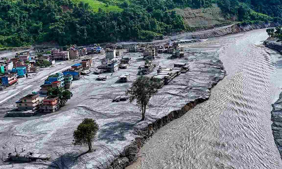
On August 26, 2026, a glacier collapsed high above the Nepal-Tibet border, sending a wall of water, mud, rock and debris through Rasuwa and Nuwakot districts and across the Gyirong crossing in Nepal. Hundreds are dead, well over a thousand remain missing, and the destruction – bridges, roads, and entire settlements – has already been covered in exhaustive detail.
Far less attention has gone to the fact that this was not the first time. It was at least the fourth time in 13 years that a Himalayan glacier, or the lake at its foot, has broken apart and killed people downstream, and the fourth time scientists had already published, in precise and public detail, that something like this was imminent.
A pattern scientists had already named
Start with the Kedarnath disaster in June 2013. Researchers had been tracking the rapid melt of the Chorabari glacier for years before record monsoon rain finally breached the glacial lake at its base, in a flood that killed more than 6,000 people – one of India’s deadliest disasters in decades.
Also read | Morgues overflow in Nepal as flash flood death toll crosses 500
Then came the Chamoli disaster in February 2021. A mass of rock and hanging glacier ice sheared away above the Rishiganga river, killing more than a hundred people and destroying two hydropower projects. What makes Chamoli remarkable is not the collapse itself but what preceded it — a government-appointed expert panel had, in 2012, explicitly warned against building hydropower projects in that river basin. The warning was overruled.
Then the Sikkim disaster occurred in October 2023. South Lhonak Lake, above 5,000 metres, had grown steadily for decades as its feeding glacier retreated. A 2021 scientific study had modelled precisely this lake’s outburst risk and effectively predicted its failure two years before it happened. When the lake finally burst, it destroyed a 1,200-megawatt dam and killed dozens of people.
And now the Nepal-Tibet border disaster has happened. This disaster sits inside a region where a joint study by the International Centre for Integrated Mountain Development (ICIMOD) and the UN Development Programme had already catalogued 47 glacial lakes across Nepal, Tibet and India as “potentially dangerous,” with 25 of them inside Tibet, upstream of Nepal.
Four disasters, three governments, 13 years — and in each case, a specific, named, published warning sitting on record before the water and debris arrived.
The science was never the missing piece
None of this required a crystal ball. High-altitude zones of the Himalayas are warming at roughly twice the global average rate, a well-established effect known as elevation-dependent warming. As temperatures climb, permafrost that binds mountain slopes together thaws, glaciers retreat and leave unstable ice behind, and meltwater collects into lakes held back by nothing sturdier than loose rock and debris.
A recent peer-reviewed study catalogued 388 glacial lake outburst floods across the wider Himalaya-Karakoram region and found that the number, area and volume of glacial lakes there have each grown by roughly half since 1990. This is not a hazard scientists failed to see. It is one they have been measuring, modelling and publishing for over a decade, lake by lake, glacier by glacier.
The gap was never in the science. It was in what happened to the science once it reached the people who could act on it.
Ignoring the experts has a body count
Each of these four disasters carries the same underlying story: a specific scientific warning, and a response that was too slow, too underfunded, or too easily overruled to matter. Chamoli’s dams were built in a basin an expert panel had already ruled unsafe. South Lhonak’s outburst risk had been modelled and published two years in advance.
The lakes now sitting on ICIMOD’s danger list are not secrets. They are catalogued, mapped and shared with the governments responsible for the people living below them. What is missing, again and again, is the translation of a scientific finding into a funded early-warning system, an enforced building restriction, or a cross-border data-sharing arrangement that moves faster than the water does.
This is the real cost of treating scientific consensus as an optional input rather than a binding constraint. Glaciologists and hydrologists are not speculating when they flag a lake or a slope as dangerous. They are describing a physical process already underway, one that will resolve itself with or without a policy response.
Also read | Killer floods: Is Nepal underprepared for natural disasters? Yubaraj Ghimire exclusive
When that expertise is set aside for the sake of a dam, a pilgrimage route, or simply the cost of building a monitoring network, the mountain does not wait for the paperwork to catch up. It settles the matter on its own schedule, and the people living downstream pay the price of a warning that was heard but not heeded.
The bill keeps coming due
There is a comforting version of this story in which the Himalayas are simply an unpredictable, dangerous place to live, and disaster is the price of geography. That version asks nothing of anyone. The less comfortable version is the true one – a mountain range that scientists have watched, measured and warned about over decades, delivering almost exactly the outcomes it was expected to deliver, at intervals that are shortening rather than lengthening.
Four disasters in 13 years is not bad luck repeating itself. It is what happens when a scientific consensus is documented, published, and then left to sit on a shelf while the underlying physics continues, indifferent to whether anyone acted on it.
The Himalayas are not withholding information. The scientists have been remarkably precise about which lake, which slope, which basin.
The only open question left is whether the next warning is acted on before the next death toll, or after it. The evidence of the past 13 years suggests South Asia’s governments have not yet decided to change that answer.